Sedona Canyons 125 Course Overview
Distance: 124.8 Miles
Cutoff: 75 Hours
Surface Distribution
Single-Track: 58% Double-Track: 25% Pavement: 17%
Elevation Max: 6,458′
Elevation Min: 3,258′
Estimated Cumulative Gain: 14,775′
Estimated Cumulative Loss: 12,463′
World Class Trail Systems: Sedona, Arizona Trail, Flagstaff Loop Trail
Journey Through Mainstreet: Jerome, Clarkdale, Sedona, Flagstaff

Course Map
Elevation Profile
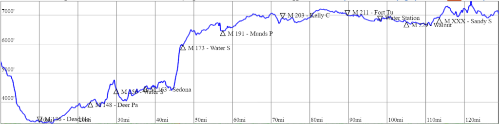
Estimated cumulative loss = 12,463′
Section Descriptions
Interested in learning even more about the course. Visit our ABOUT THE COURSE page.
Training on the Course
Not planning a 125 off the couch? It might be a good idea to get some training miles under your belt before May. We encourage you to get out on the course but there are some items you need to be aware of:
- Private Property – There is one big section of private property the race crosses just below Jerome. We have graciously been given approval to cross this area during the race but they are NOT open to the general public.
- Conditions – Be cognizant of your impact if it rains. If it is too muddy, run a different trail.
- Gates – It’s simple but very important…if you find a gate closed, close it behind you. If you find a gate open, leave it open.
Here is a link to the PUBLIC sections of the course (note that this is the full 250-mile course) with sections of private property removed. We have also slightly altered the course and broken it up into 11 sections (for the 250-mile course) that start/end at trailheads to make it easier for shuttle logistics. Obviously, you can start/end a training run wherever you would like, we’re just trying to make it easier for you. Here are the sections:
- Section E – 13.7 Miles – Dead Horse Ranch State Park to Deer Pass Trailhead
- Section F – 12.4 Miles – Deer Pass Trailhead to Sunset Park
- Section G – 30.7 Miles – Sunset Park to Munds Park
- Section H – 19.7 Miles – Munds Park to Fort Tuthill
- Section I – 17.2 Miles – Fort Tuthill to Walnut Canyon Trailhead
- Section J – 21.5 Miles – Walnut Canyon Trailhead to Heritage Square
For a little bit of background on each section, checkout our “about page”.
GPS Enabled Device (Mandatory)
During the race, it is MANDATORY to carry a gps enabled device with the course file downloaded. This device can be a handheld GPS unit, watch, or smartphone. The smartphone is the easiest and least expensive option. To use a smartphone, install a mapping App such as Gaia, GuruMapsPro, TrailForks, or AllTrails to your phone. Then download the course GPX file from CalTopo (PUBLIC sections only or Entire Course) and open the file in the mapping App. The course will appear, as well as your location (blue dot). Badabing Badaboom. Protip – Place your phone in airplane mode to maximize battery life.
Any other question? Feel free to email the Race Director.
Happy Running!