Cocodona250 Course Overview
Distance: 252.0 Miles
Cutoff: 125 Hours
Surface Distribution
Single-Track: 42% Double-Track: 48%
Pavement: 10%
Elevation Max: 9,241′
Elevation Min: 1,996′
Estimated Cumulative Gain: 40,143′ (2024)
Estimated Cumulative Loss: 34,907′ (2024)
World Class Trail Systems: Black Canyon National Recreation Trail, Prescott Circle Trail, Sedona, Arizona Trail, Flagstaff Loop Trail
Journey Through Mainstreet: Crown King, Prescott (Whiskey Row), Jerome, Clarkdale, Sedona, Flagstaff

Course Map
Elevation Profile
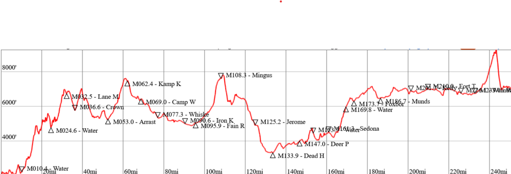
Estimated cumulative loss = 34,907′ (2024)
Section Descriptions
Interested in learning even more about the course. Visit our ABOUT THE COURSE page.
GPS Enabled Device (Mandatory)
During the race, it is MANDATORY to carry a gps enabled device with the course file downloaded. This device can be a handheld GPS unit, watch, or smartphone. The smartphone is the easiest and least expensive option. To use a smartphone, install a mapping App such as Gaia, GuruMapsPro, TrailForks, or AllTrails to your phone. Then download the course GPX file from CalTopo (PUBLIC sections only or Entire Course) and open the file in the mapping App. The course will appear, as well as your location (blue dot). Badabing Badaboom. Protip – Place your phone in airplane mode to maximize battery life.
Course Records Cocodona250
| Male | Female | Non-binary |
| ’24 Haroldas Subertas 59:50:55*** | ‘23 Sarah Ostaszewski 72:50:27*** | |
| ’22 Joe McConaughy 59:28:54** | ’22 Annie Hughes 71:10:22** | |
| ’21 Michael Versteeg 72:50:25* | ’21 Maggie Guterl 85:30:38* |
*Original Course “The Hard Year” – Left Sedona west to climb Coconino Plateau via Casner Mountain Grade
**Crooks Fire Reroute “The Easy Year” – Start in Prescott w/ counterclockwise loop & Skull Valley out-n-back
***Current Course – Minor course changes happen every year but this record was set on the current course
Course Questions?
Any other question? Feel free to email erika[@]aravaiparunning[dot]com.
Happy Running!
